I investigate the interface between fluid mechanics and geomorphic hazards. I use data analysis, remote sensing and models to study feedbacks between river meandering & landsliding and how sediment in channels can affect flood hazard.
PROJECTS
Feedbacks between landsliding and river meandering
"Are there systematic patterns between deep-seated landslides and river form in western Washington State?"
2023-Present

Landslides that occur in river valleys can be large, highly mobile, and cause cascading downstream hazards associated with landslide dams and elevated flood risk. However, the role of rivers in triggering landslides is not well understood. Here, we investigate 89 years of landsliding and river dynamics along a 2.5 km section of the Nooksack River in western Washington State where the channel is flanked by landslide-prone glacial terraces similar to those that failed in the 2014 State Route"Oso" landslide. We observe dynamic feedbacks between lateral river meandering and valley-adjacent landsliding: deep-seated landslides occur on persistently pinned outer meander bends. Landslides extending into the active valley width into the floodplain can displace the river away from the floodplain margin and change the channel planform. River‐displacing landslides relocate meanders up‐ or downstream, thereby conditioning the location of subsequent landslides. This conceptual model of coupled landslide‐driven meander displacement and valley‐adjacent landsliding is exemplified across western Washington river systems. The distance between up‐ and downstream valley‐adjacent landsliding scales with valley width, meander wavelength, and terrace height. These results can advance our understanding of the river-hillslope interface in landscape evolution and can be used to inform hazard management in river corridors.
Ahrendt, S. M., Mirus, B. B., LaHusen, S. R., & Perkins, J. P. (2025). Dynamic feedbacks between river meandering and landsliding in northwestern Washington glacial terraces. Journal of Geophysical Research: Earth Surface, 130(8), e2024JF008249. https://doi.org/10.1029/2024JF008249
Feedbacks between overbank flooding and deposition
"Does the within-event pattern of flooding influence patterns of in-channel deposition?"
2021-Present
In 2021 an atmospheric river event caused extensive flooding in northwestern Washington and British Columbia. Of particular concern, was trans-boundary flooding from Nooksack river water overflowing at a persistent overflow region and historic avulsion node. We observe coincident within-event deposition at this site, which as potential for exacerbating flood hazards. Here, we leverage three dimensional hydro-morphodynamic Delft3D modeling to understand feedbacks between overflow and in-channel deposition in this important region. The figure to the right demonstrates our conceptual model of how overbank flooding can exacerbate in-channel sedimentation.

River Bed Morphodynamics During & Between Floods
"Can spatial changes in river planform geometry predict regions prone to erosion and deposition during floods?"
2021-Present
Understanding how river beds change during peak flows and recover between events is challenging because measurements of bathymetry and sediment-transport are often sparse or unavailable. Here, we use high resolution bathymetry data from the Waal River in the Netherlands to analyze whether spatial changes in floodplain geometry can explain bed elevation changes during and between high flow events. The image below depicts a conceptual understanding of how the bed responds to spatial changes in flood extent in a river with uniform channel width but varying floodplain geometry.

Ahrendt, S. M., Blom, A., Van Denderen, R. P., Schielen, R. M. J., Horner-Devine, A. R., (2024) Geometric floodplain controls on riverbed elevation change within and between flood events , River Flow 2022 (1st ed.) CRC Press. https://doi.org/10.1201/9781003323037-43 [PDF]
The role of streamflow vs. channel conveyance in flooding
"How do the ways rivers transport sediment affect flooding?"
2018-2022
Flood hazards in most basins are typically assumed to be driven by the frequency and intensity of high discharge events, but changes in a river’s conveyance capacity can also contribute substantially to flood hazards. Take the channel shown in the figure on the right where Q-bankfull is the bankfull flow capacity of the channel. This river section can flood by two mechanisms. 1: it can experience a discharge event ‘Q’ that exceeds Q-bankfull, or 2: sediment can deposit in the channel changing the channel’s conveyance capacity and causing water to flow overbank for what was previously a Q-bankfull event. It’s these changes in channel conveyance capacity that we are trying to understand in order to improve flood risk predictions.

Investigate the results here!
Ahrendt, S., Horner-Devine, A. R., Collins, B., Morgan, J., Istanbulluoglu, E., (2022) Channel Conveyance variability can influence flood risk as much as streamflow variaibility in western Washington State, Water Resources Research. https://doi.org/10.1029/2021WR031890
This collaborative project is funded as part of the NSF PREEVENTS program.
Rapid Groundwater Modeling: Method Development
"How can we improve rapid-aquifer level predictions by incorporating real-time data into physical models?"
2017-2018
Three-dimensional groundwater models can be time-intensive to calibrate and computationally-costly to run. Here, we propose a method for rapid groundwater modeling by calibrating recharge to a MODFLOW groundwater model to reported groundwater level or 'head' measurements. The figure below shows how these measurements (evident as little high-elevation contour points) are iteratively smoothed in a MODFLOW model of an unconfined region of the Mahomet Aquifer in Mason County, Illinois. This "Head-Specified" method provides a continuous aquifer surface at reduced computational times and calibration efforts.

IPython Instructional Notebooks
Teaching model development with visual support
2017-2019
I am passionate about developing graphical support for teaching and research. Here, I developed instructional material for the Illinois State Water Survey to teach groundwater modeling using Python and Flopy.
Click the figures below for tutorials on:
1) Steady-state confined aquifer model
2) Steady-state model with a pumping well
3) Transient model with a river


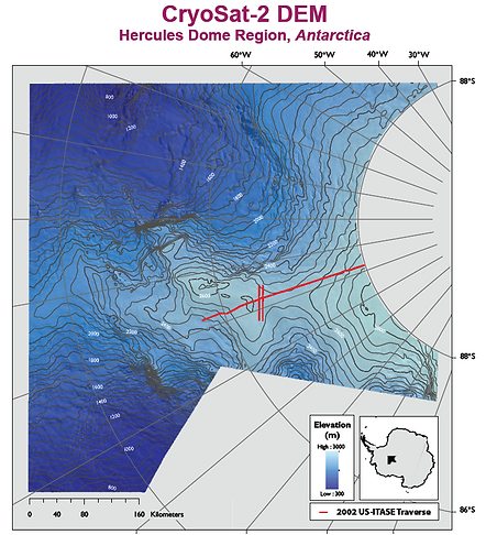
Hercules Dome, Digital Elevation Model
Summer 2016
The goal of this project was to identify the optimal location for deep antarctic ice core drilling. In contribution, I created a Digital Elevation Model from CryoSat-2 radar altimetry data to be used in focusing ground-based surveying. The project was conducted at the St. Olaf Center for Geophysical Studies of Ice and Climate under the advice of Dr. Robert Jacobel as part of the St. Olaf College CURI undergraduate research program.
Read more in our AGU Fall 2017 abstract.
PEER-REVIEWED PUBLICATIONS
-
Ahrendt, S. M., Blom, A., Van Denderen, R. P., Schielen, R. M. J., Horner-Devine, A. R., (2024) Geometric floodplain controls on riverbed elevation change within and between flood events , River Flow 2022 (1st ed.) CRC Press. https://doi.org/10.1201/9781003323037-43 [PDF]
-
Ahrendt, S., Horner-Devine, A. R., Collins, B., Morgan, J., Istanbulluoglu, E., (2022) Channel Conveyance variability can influence flood risk as much as streamflow variaibility in western Washington State, Water Resources Research. https://doi.org/10.1029/2021WR031890
-
Morgan, J. A., Kumar, N., Horner-Devine, A. R., Ahrendt, S., Istanbullouglu,
E., Bandargoda, C., (2020), Simulating large-scale and long-term fluvial morphodynamics: The efficacy of using a morphological acceleration factor. Geomorphology, 356, p. 107088, https://doi.org/10.1016/j.geomorph.2020.107088
SELECTED PRESENTATIONS
-
Ahrendt, S. (Presenter), Mirus, B., LaHusen, S., Perkins, J., "Feedbacks between river meandering and glacial terraces" USGS Landslide Hazards Program Seminar (July, 2024) Online.
-
Ahrendt, S. (Presenter), Blom, A., VanDenderen, R. P., Schielen, R. M. J., Horner-Devine, A. R., "The influence of floodplain geometry on riverbed elevation change within and between floods." Poster Presentation at the Netherlands Centre for River Studies, NCR-Days Conference (April 2022) Delft, The Netherlands
-
Ahrendt, S. (Presenter), Horner-Devine, A., Kumar, N., Morgan, J. A., Collins, B., Istanbulluoglu, E. “Understanding Morphologic Flood Risk Relevant to River Management in Western Washington State” Oral Presentation at the American Geophysical Union Fall Meeting (Dec, 2020) Online
AGU 2020 Virtual Presentation
-
Ahrendt, S. (Presenter), Horner-Devine, Kumar, N., A., Morgan, J. A., Collins, B., Istanbulluoglu, E. “River Morphology and Flood Risk in the Pacific Northwest” Oral Presentation at the Community Surface Dynamics Modeling System: Summer Science Series (July, 2020) Online
CSDMS Summer Series 2020, Virtual Presentation
-
Ahrendt, S., (Presenter) A. Horner-Devine, N. Kumar, J. Morgan, B. Collins, E. Istanbulluoglu, C. Bandargoda, A. Pfeiffer, "How is channel capacity connected to flood risk in high sediment supply mountain basins?" Oral presentation at the American Geophysical Union Fall Conference (Dec, 2019) San Francisco, CA
-
Ahrendt, S., (Presenter) Morgan, J. A., Horner-Devine, A., Kumar, N., Keck, J., Duan, Z., Istanbulluoglu, E., Bandaragoda, C., Collins, B., Pfeiffer, A., "A mountain-to-coast hydrogeomorphic modeling framework for flood risk prediction" Poster Presentation at the Comminty Surface Dynamics Modeling System Meeting (May, 2019) Boulder, CO
-
Ahrendt, S. (Presenter), Istanbulluoglu, E., Horner-Devine, A., Mauger, G., Bandaragoda, C., Collins, B., Lundquist, J., Montgomery, D., Kumar, N., Shean, D., Pfeiffer, A., Morgan, J. A., Duan Z., Riedel, J., Kennard P., Anderson, S., Jaeger, K., Whorton E., "Integrated Modeling of HydroGeomorphic Hazards (MoHGeoH): Floods, landslides and sediment" Poster Presentation at the National Science Foundation PREEVENTS PI Meeting (Sept, 2018) Washington D.C.
-
Ahrendt, S. (Presenter), Abrams, D. "A Head-Specified Model; Concept Proof and Application in the Mahomet Aquifer", Presentation at the Mahomet Aquifer Consortium Meeting (July, 2018) Urbana, IL
-
Abrams, D. (Presenter), Ahrendt, S., Hadley, D. "Moving toward a real-time model of groundwater/surface water interactions in two heavily irrigated systems" Presentation at the International Congress on Environmental Modelling and Software (Jun, 2018)
-
Ahrendt, S. (Presenter), Jacobel, Christianson, Steig, Porter (2016). "A New Digital Elevation Model for Hercules Dome, Antarctica from CryoSat-2 Altimetry – Toward Site Selection for the Next Antarctic Deep Ice Core." Poster presentation at the American Geophysical Union Fall Conference (Dec, 2016).
FIELD NOTES
Observing Sediment Transport Processes in Northern Minnesota:
Field Exercise for Hillslope Geomorphology with Dr. Alison Duvall
Map of Study Sites: Magnetic Rock Trail, MN


